What's Hot: 1,800 Units In The Works: Connecticut Avenue's Building Boom | New EYA Townhomes Just Steps to Metro
 Google Maps Launches Live Public Transit Alerts for DC
✉️ Want to forward this article? Click here.
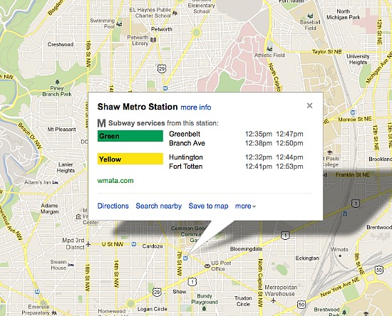
Courtesy of Google Maps.
Google Maps announced updates today for its tracking of live departure and arrival times for DC’s bus and subway system.
From the Google Maps blog:
Riders on the nation’s second largest subway, Metrorail in Washington, D.C., can now see live service alerts, including unplanned delays and scheduled track work, straight from Metro’s Control Center on Google Maps. To adjust your travel around the alerts you see, simply choose another suggested route or change your departure time.
Given DC’s previous attempts at tracking public transit arrival and departure times, we will be interested to see how the update will affect the accuracy of the tool.
Similar Posts:
- Google Showcasing SketchUp Designer Creations
- Do Google Searches Predict the Direction of Home Prices?
See other articles related to: google, google maps, google transit
This article originally published at http://dc.urbanturf.production.logicbrush.com/articles/blog/google_maps_updates_live_public_transit_alerts_for_dc/6845.


UrbanTurf Listings showcases the DC metro area's best properties available for sale.

Most Popular... This Week • Last 30 Days • Ever

EYA and the Washington Metropolitan Area Transit Authority have requested a two-year ... read »

While the broader DC-area housing market grapples with elevated mortgage rates and ca... read »

Justice Roberts selling Maryland home; bathroom danger; and what will future stadiums... read »

From the Maryland line down to the edge of downtown, a mix of office conversions, inf... read »

UrbanTurf is once again taking its semi-regular look at the areas around DC that have... read »


DC Real Estate Guides
Short guides to navigating the DC-area real estate market
We've collected all our helpful guides for buying, selling and renting in and around Washington, DC in one place. Start browsing below!
First-Timer Primers
Intro guides for first-time home buyers
Unique Spaces
Awesome and unusual real estate from across the DC Metro