 Navy Yard to Ward 8, Kingman Park to Ward 6: Final Map of New Ward Boundaries Released
✉️ Want to forward this article? Click here.
Two weeks after the DC Council Sub-Committee on Redistricting released three hypothetical maps showing how DC's ward boundaries could be redrawn to compensate for recent population changes, the final map is up for approval.
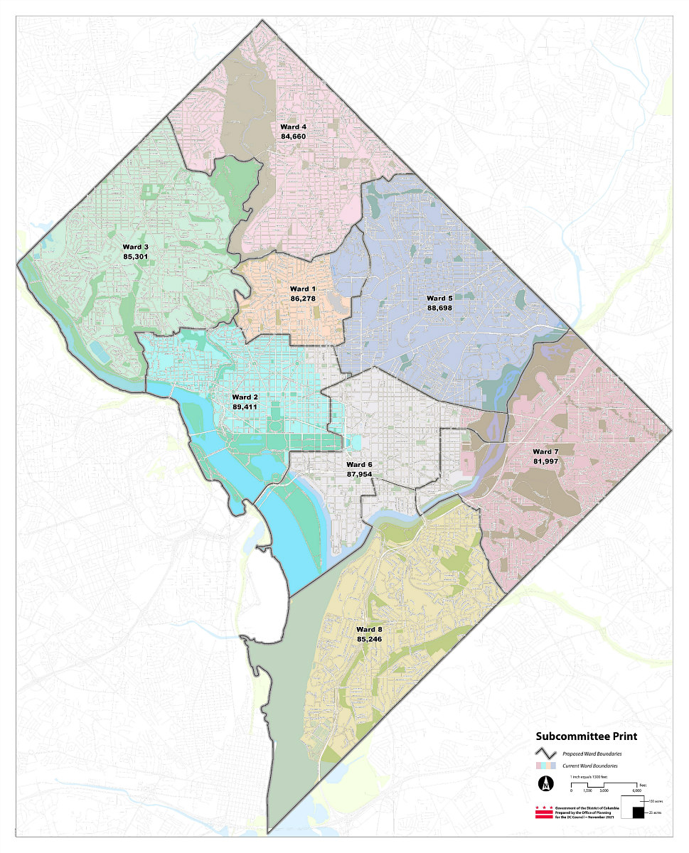
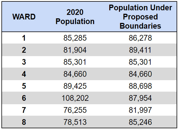
The final map adapts many of the principles of those maps, combined with other points raised in recent public testimony and debate. The latest U.S. Census population count showed a vastly over-populated Ward 6 and under-populated Wards 7 and 8; with the new citywide population count, each ward should have an average population of 86,190 people, ±5%.
story continues below
loading...story continues above
The map released Thursday leaves the boundaries of Wards 3 and 4 intact and transfers the Navy Yard neighborhood from Ward 6 to Ward 8 (minus the blocks southeast of South Capitol Street and 695 and northwest of New Jersey Avenue and M Streets SE). Ward 7 gains the portion of Hill East southeast of 15th and C Streets, ending at Potomac Avenue and 11th Street SE, in part adding more economic development to Ward 7 courtesy of Reservation 13; meanwhile, Kingman Park becomes part of Ward 6 instead of Ward 7, restoring cohesiveness west of the Arboretum and ensuring more racial diversity in Ward 6.
The Armed Forces Retirement Home is shifted from Ward 5 to Ward 1, and Ward 6 loses the portion of Shaw and Mount Vernon Square north of New York Avenue NW to Ward 2. Ward 6 also gains the portion of Ward 2 that is northeast of Pennsylvania Avenue and 5th Street NW, and Ward 1 gains the three blocks between Florida Avenue and S Street just west of New Jersey Avenue NW from Ward 6.
Subcommittee Chair Elissa Silverman noted that many of these decisions were made because they were the best of the tradeoffs available to make the population numbers work and create or maintain diversity. Councilmember Christina Henderson noted that the subcommittee wanted to avoid neighborhood "islands" and to ensure that the population distribution was conducive to creating full Advisory Neighborhood Commissions (ANCs) when the ANC redistricting process commences next year.
The bill that proposes new boundaries will freeze parking permits in place, and boundaries for school, police districts and the like remain unchanged. The redistricting subcommittee will markup and vote on the bill tomorrow afternoon; the DC Council is expected to pass a final redistricting bill on December 21st.
Similar Posts:
See other articles related to: census, dc council, dc wards, population, redistricting, u.s. census, ward 1, ward 2, ward 5, ward 6, ward 7, ward 8
This article originally published at http://dc.urbanturf.production.logicbrush.com/articles/blog/dc-redistricting-subcommittee-releases-final-map-with-new-ward-boundaries/18968.
Most Popular... This Week • Last 30 Days • Ever

Today, UrbanTurf takes a look at the distinct differences between these two popular f... read »
The largest residential conversion planned in the neighborhood is continuing to move ... read »

DC restaurant Pascual makes national best new restaurant list; Minetta Tavern is abou... read »
Despite it being a slower year for the housing market in the DC area, there are two B... read »
The rising fees that come with homeownership; Virginia toll road costs RV driver near... read »
DC Real Estate Guides
Short guides to navigating the DC-area real estate market
We've collected all our helpful guides for buying, selling and renting in and around Washington, DC in one place. Start browsing below!
First-Timer Primers
Intro guides for first-time home buyers
Unique Spaces
Awesome and unusual real estate from across the DC Metro


