 The Nation's Capital, Courtesy of Cold War Cartography
✉️ Want to forward this article? Click here.
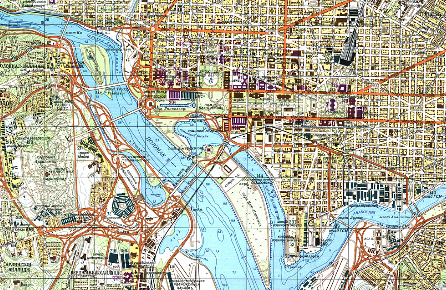
Click to enlarge.
During the Cold War, the USSR military mapped out much of the world in painstaking detail — including the Nation’s Capital.
The Architect of the Capitol recently published the DC map which, along with the general lay of the land, itemized several technical points — down to street widths, the precise location of infrastructural systems and industrial sites, and bridge’s load-bearing limits.
Interestingly, the map is more detailed than many maps commonly used today — often with features that have little tactical value — however it omits a range of locales and notes that are arguably of vital importance.
story continues below
loading...story continues above
In this way, the map stands as a snapshot of the Soviet Union’s effort to crowdsource everything they knew of the District at the time. While it would be of little practical use in the GPS-era, the map was very ahead of its time when it was created in the 1970’s.
Various features of military sites on the map are exhaustively noted, down to the runways, paths and natural and man-made water features. All of the city’s reservoirs and pumping stations are recorded, as are street names throughout the city and close-in suburbs.
However, not everything is documented beyond reproach, as some building footprints, whether due to human error or distorted aerial imaging, are clearly approximations. There are also some street names, designations and labels that have been lost in translation.
John Davies first discovered the Soviet Cold War maps in Latvia in the early 2000s; others in the collection are available on his website.
See other articles related to: dc, infrastructure, maps
This article originally published at http://dc.urbanturf.production.logicbrush.com/articles/blog/the_nations_capital_courtesy_of_cold_war_cartography/11584.


UrbanTurf Listings showcases the DC metro area's best properties available for sale.

Most Popular... This Week • Last 30 Days • Ever

In this article, UrbanTurf explores what renters insurance is and what it covers.... read »

The largest waterfront redevelopment planned in the DC region in years has cleared it... read »
What will it take to get the H Street Corridor back on track? A new report from the D... read »

A renovation proposal is taking shape for a prominent historic office building along ... read »

New renderings have surfaced for one of the largest condominium developments on the b... read »


DC Real Estate Guides
Short guides to navigating the DC-area real estate market
We've collected all our helpful guides for buying, selling and renting in and around Washington, DC in one place. Start browsing below!
First-Timer Primers
Intro guides for first-time home buyers
Unique Spaces
Awesome and unusual real estate from across the DC Metro